

Then we get photos like this one, again from the John C. Gordon collection at San Jose State. Go off and look at the full photo for a moment, then come back here; it's worth examining in detail.
Now, the photo's pretty innocuous - brick warehouse, lots of Western Pacific cars, non-specific industry name, some late 1920's color (like billboards and probably a Model A). My first guess would be that it's some random industry on the WP in San Jose, but a quick glance through Track and Time's track diagrams don't hint at any likely sites around San Jose... nor in Oakland.
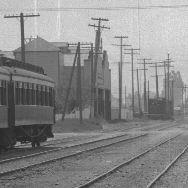


So what we really have here is a photo of a warehouse along the former Cahill Street just south of the Alameda / Santa Clara Street and north of San Fernando Street. These warehouses would be disappearing in a few years, torn down so Diridon Station can be built on this exact location. If I could read that truck license plate towards the right of the photo, I might even be able to guess at the year of the photo, or perhaps the "Kopp's Transfer" gives another detail.

I still have no clue why Material Supply Corp. is receiving so many WP cars. Maybe the SP was remarkably friendly during the 1920's about spotting cars for the WP. Maybe those ICC reciprocal switching rules were iron-clad, even when the cars needed to be delivered to an SP-owned building. Or maybe Material Supply was getting most of its incoming supplies from the WP...
But the photo does highlight what the West San Jose area looked like before Diridon Station went in, and it almost convinces me to backdate my layout a couple years. I've modeled this area as if the construction and track raising for Diridon Station had started in 1932 or 1933, but the area for these warehouses is just an underused siding and a temporary station in a passenger car up on blocks. If I was willing to get rid of the Alameda underpass and the slightly raised ground level, I could get a lot of traffic from that warehouse... and I'd also get the advantage of the insane traffic levels that would be prototypical in the late 1920s.
Got ideas why there's so many WP boxcars spotted here, see something interesting in the picture, or got an opinion on whether I should move my layout back a few years? Add a comment and throw in your two cents!
Three observations:
ReplyDelete1) The reweigh dates are all around 1923.
2) The car at the left is probably a Model T, not a Model A.
3) I thought the white dots on each car door were dabbed on the photo, but I think they actually read "cement". If the cement was coming from an industry on the WP, that might explain the density of WP cars here.
Robert,
ReplyDeleteI need to follow you blog more often....
For the past year, I have worked as an intern at History San Jose in their collection center (the former Beechnut factory). One of the results of my HSJ involvement is the transportation exhibit in the Diridon Depot lobby.
During my research for the exhibit, I came across a bound book of a 60 plus images taken by SP along the proposed mainline rerouting. The images are of nearly every proposed road crossing from differing vantage points. The images were taken in the late 1920s starting about Taylor Street and continuing south to about Curtner.
Nonetheless, I was surprised at the number of on-line customers near the West San Jose depot, including this structure in the Gordon image.
The images may be useful for your research.
Ken Middlebrook
Hi, Ken,
ReplyDeleteThanks for the lead! I'd definitely be interested in checking those photos out - is the book in the display right now, or is it available for examination in the HSJ archives?
The album is available at the HSJ archives. Catalog #1997-221-2. The associated 82 images were taken September 1928.
ReplyDeleteKen
Looks I need to find a free day and wander over to the HSJ archives. Thanks for the pointer!
ReplyDeleteSide note: the 1891 Sanborn maps available from U.C. Santa Cruz labels these warehouses as the "Brown and Barker's Grain Warehouse / SPCRR owner. It's easy to forget how big the grain business was in the Santa Clara Valley til you realize how many of the railroad-related buildings were for the grain trade.
ReplyDeleteThe picture of Kopp's transfer suggests that's the company's only truck, and the guy standing next to the truck is Mr. Alfred Kopp himself.
ReplyDeleteKopp's Transfer is Alfred Kopp, living south of downtown at 430 2nd Street. Kopp was in the 1925 and 1928 city directories with occupation listed as "drayman", but by 1930 listed his occupation as salesman.
The truck appears to be a Model T or one of its variants, and the license plate seems to say it's a 1923 plate. The 1923 city directory lists Kopp as an expressman.