

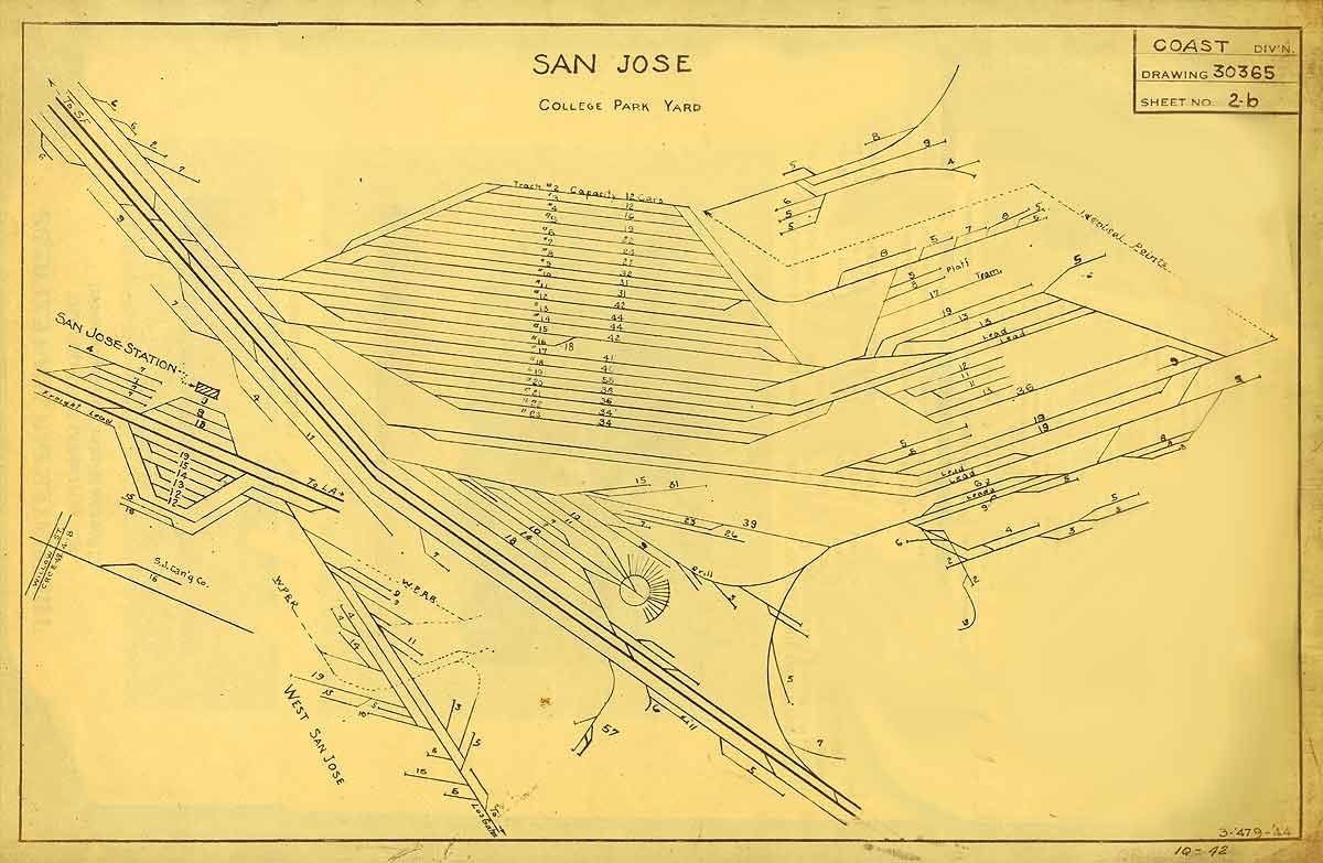
Cars to Alameda got "61", Oakland "62", and Lawrence and Atherton "35". The tags hint at the likely ranges of the different switch jobs, and how work was partitioned; Campbell was treated differently from Auzerais St. because it would have been outside yard limits and thus served by road crews.
Er, no.
Jason Hill from the La Mesa Model Railroad Club at the San Diego Model Railroad Museum corrected me here. He says it well, so let me just quote him:
Do be aware that there's a difference between "Yard Limits" and "Switching Limits". They are sometimes the same physical locations, but not always and their root reasons for existing are TOTALLY different. "Yard Limits" are a operating rules issue (Rule 93). "Switching Limits" are a crew agreement & labor issue.
For example, Yard Limits at Bakersfield extend only to the crossovers at Magunden (3 miles of out of the 'main yard'), however the "Switching Limits" extended all the way out to the far end of Edison (about 8 miles). The result of this was that the packing sheds at Edison were worked by a yard crew, under yard labor agreements, not road crews.
As a modeler you might say 'who cares what labor agreement they were under'. The answer is that the road crews have to be provided with a "caboose" which complies with a Union-agreed on defined. A 'yard job' did not have to have a "caboose" as defined by the Unions. This is not to say that the yard crews didn't grab a caboose, or a 'crew riding car', but by the Union Agreements it didn't have to have things like a stove, ice box, bunks, etc.
So for the Vasona Branch, that means that while yard limits moved back and forth over the years, all that said was whether the crew needed permission from the dispatcher to be on those tracks (though it also hints at whether the traffic was dense enough to require more control over who was blocking the tracks.) As Jason points out, crews running to Campbell inside or outside of yard limits could have been road crews, or switcher crews from the San Jose yard. His comment about cabooses also highlights that my all-yard-limits job from San Jose Yard to Auzerais Street may or may not have needed a caboose; I'd probably have a plausible story for either choice in the absence of any photos suggesting how Things Got Done in San Jose in 1932.
However, that makes the list of car routing tags from track directory that much more meaningful, because if two cars were being tagged for the same destination, then it's pretty likely that they were being sorted together, and were going out on the same train for delivery. All cars for the Almaden Branch were tagged with one number; that's not surprising, as 1928-era timetables showed that the Almaden branch was served by a weekly scheduled train that went to Almaden via Campbell, and went back via Hillsdale and the main line. The car routing tags also group all the cars destined for Campbell to Santa Cruz together, suggesting that all those stations were served off the same train. (That was a Tuesday train in case you're planning a time-travelling road trip.) There's photos from later in the 1930's showing short, six car trains going towards Los Gatos, and the routing numbers suggest that train would also have been dropping off cars in Campbell.
None of this hints whether that train from Campbell to Santa Cruz handled only those towns; although the Lincoln Ave. canneries and fruit packing plants had their own routing tag, the answer's hazy about whether Lincoln Ave. was handled with a local switch crew from the yard, or whether the train from San Jose to Santa Cruz handled the work.
And I still don't know whether the routing tags were stapled pieces of paper like on the Santa Fe, or were just written in chalk. The photo of the Material Supply Warehouse at the station at West San Jose suggests chalk as one of the WP boxcars has a prominent "13" written in chalk across it - that's the routing tag for the WP Interchange, though it seems wrong that a car still at the industry would already be tagged. I don't see any signs of paper tags on any of the visible cars.
Anyway, that's the logic-puzzle fun of historical research when there's no crews around who can tell you how they worked. Maybe some conductor's books from the 1930's would help, or maybe there's some train orders hinting at how the freight trains on the branch operated. But til then, I'll need to do a combination of guessing at what the railroad really did, and also remember to break the historic rules when it might make operations on the layout less fun.

