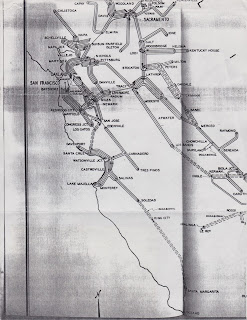
And today, another installment in the "if I find something interesting, scan it and put it on the internet" department. Let me know what you find in this!
Our local model railroad organization, the Pacific Coast region of the National Model Railroad Association, has quarterly meets; I haven't been in the habit of attending, but decided to visit for a change this month. The Sunday event includes some presentations, some demonstrations and contests, and a well-known auction of model railroad equipment. I put in a few bids on some a few items, including some out-of-production models and a box full of random books and paper. I went after the box primarily for the book on top, but my low bid still managed to let me win. And while the book was nice, there were some interesting finds in the box - a menu from Krushchev's train trip between Los Angeles and San Francisco, some post cards, and an interesting map.
And that map deserves a bit of attention.
The map shows railroad routes in Northern California; a note on the back explained that it came from a 1938 California Railroad Commission report showing the "routes taken by Southern Pacific local freights" - that is, it showed where freights going between towns typically started and ended, and which routes were only rarely served. For someone like me interested in reproducing how trains and crews actually worked, the map hints at which yards were busiest, which way freights went, and which locations were expected to have heavier traffic.
Some quick looks at the map show some interesting facts. Look first at Edenvale, just south of San Jose. Although Edenvale was only a few miles south of San Jose, the map indicates that trains from Watsonville Junction actually handled Edenvale boxcars as part of switching Gilroy, Hollister, Tres Pinos, and other places south of San Jose, all in one big loop. Congress Junction, located out by Cupertino was switched by crews from the San Jose yard, but usually by going up to Redwood City, looping down the Mayfield Cutoff through Los Altos and Cupertino, then turning around and heading back to Mayfield (California Ave. in Palo Alto) and returning to San Jose. Danville was more commonly switched by trains from Pittsburg and Port Costa, while trains from King City might be served from far-away Watsonville Junction or Santa Margarita.
Up north in the Capay Valley along the west side of the Sacramento Valley, the trains and crews came from Sacramento and not the nearer Fairfield or Vacaville. Trains from Sacramento to Placerville appeared to have enough business so the train crews couldn't just go up and back, but instead would start and end shifts at the end of the Placerville branch.
For my Vasona Branch, the obvious lessons are "don't run trains to Edenvale", "trains to Los Gatos are really rare", and "don't expect trains to arrive at Vasona Junction very often". If I'd known all this before I'd built my layout, I might have been tempted to downplay Campbell and Los Gatos, or at least to omit Vasona Junction in favor of a nice scene including Sewall Brown's apricot pit plant. But at some point, the model railroad is about fun, not accuracy, so when you come to operate on the Vasona Branch, prepare to see an unnatural number of trains passing through Campbell...
What do you see? Add any comments about the maps in the comment section, and help share some of the unexpected oddities of 1930's era freights!


