


Southern Pacific train #84 rolling into Glenwood around 1913.
A few weeks back, I finally started redoing scenery on a long-ignored part of the layout: Glenwood, on the upper deck. When I first built the Vasona Branch layout, I’d thrown in some temporary scenery... which has lasted for a good fifteen years now. Before I show off what I’ve been doing, though, let’s chat a bit about Glenwood.
As we read in the abandonment filing, there wasn’t a lot to do in the Santa Cruz Mountains in the 1930’s: little industry, few people, and a railroad line that tended to get buried in mudslides every winter. The Los Gatos-Santa Cruz branch wasn’t a happy place for a profit-focused railroad.
My Vasona Branch layout models the Santa Cruz Mountains on the upper deck, both for extra mileage and for my chance to model some classic California scenes. I chose to model three locations on the layout: Alma, Wrights, and Glenwood. I chose each for scenery and track arrangement reasons. Alma and Wrights were both on the uphill side of the climb to the summit, so they made sense for the slowly-rising upper deck. I chose Alma because I wanted its passing siding, and because I could find photos of the station. Wrights was an obvious place to include; the track comes up the narrow canyon, then makes a sweeping curve across Los Gatos creek to dive into the summit tunnel. The creek and bridge, toy station, tunnel, general store, and historic location made it photogenic and proper for the layout.
But what about the Pacific side of the line? I could have modeled Felton, with its lumber mill. I could have modeled Laurel, with its tiny station sandwiched between two tunnel portals, and side-hill trestles keeping the track from sliding down into a canyon. Glenwood, however, had a tight curve at one end of town that led to the Glenwood-Laurel tunnel, just perfect for the curve on the layout, which made the model in the garage match the real-life terrain. But in the 1930’s, Glenwood was near abandoned: a main line, two weed-infested sidings, and a closed station. So why include it?
Glenwood had been much more important in the narrow gauge days. Bruce MacGregor notes that Glenwood was nearly at the elevation of the summit tunnel; if the South Pacific Coast railroad could pull lumber and other freight to Glenwood, they could easily pull it through the tunnels and down to Los Gatos and San Jose with a single engine. As a result, Glenwood originally had multiple sidings for assembling larger trains before pulling them to the Santa Clara Valley. Glenwood also had a turntable for turning the locomotives hauling the lumber up from Boulder Creek and Felton, and a couple sidings for maintenance-of-way.
Beyond that, Glenwood wasn’t particularly exciting. Tunnel at the west end of town to Laurel and the summit, bridge over the creek at the south end (and eventually leading to the tunnel to Zayante and Felton), the depot, a general store, a winery that looked more like a barn, and a few houses. Some resorts were scattered in the trees, but it wasn’t the most cosmopolitain of places. It made up for its meekness with stories from the early settlers, including “Mountain Charlie” McKiernan, who famously fought a bear and got a dent in his skull.
The California State Railroad Museum has the station plan drawings for multiple years, giving us a chance to see the evolution of Glenwood from the railroad’s point of view for four times: November 1907, December 1907, 1913, and 1939.
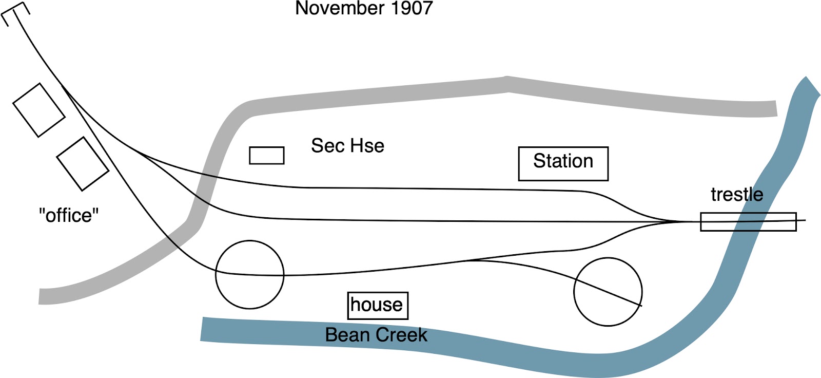

A month later in December 1907, the SP created another map, probably showing line changes after standard gauging and reopening the line. There’s now just two sidings and the main line, with a spur in front of the depot. Bean Creek’s now been filled in with a concrete culvert.

The 1913 map shows additional changes. This map labels the building next to the Laurel tunnel as “watchman’s house”. There’s also two spurs, probably for maintenance-of-way. There’s a couple photos from about this era showing trains passing the semaphores just before the tunnel. Those photos caught maintenance of way cars - or bunk cars - sitting on the siding. On the east end of town, longer sidings both cross the new culvert to create 1100 foot sidings for longer standard gauge tracks. The maps also show the block signals at each end of town. A private road loops over the top of the tunnel portal; this will eventually be the Glenwood Highway.

So what do I want from all these sights? I’m not changing the track layout, so we’ll still have the curve into the Glenwood-Laurel tunnel. The Glenwood Highway looping over the top of the tunnel portal is a well-known design, so I’ll need to keep that. The depot’s small-ish, photogenic, and has an appropriate location so we’ll need to keep it. (I’ve got a placeholder model based on some plastic kit, but it’s time to make an accurate version.). I hadn’t known about the section house and tool house; there’s space for both next to the depot, so those deserve to be added.
What’s already there? The old scenery has the Glenwood highway curving over the tunnel portal, but the climb out of town is jerky and doesn’t look smoothly. There’s also a house on stilts right next to the tunnel portal. It’s unprototypical; that hillside looks like it was mostly trees and bushes. It’ll need to go. I’d also cut a space for one of the abandoned turntables. Stories suggest that the turntable was filled in, but I’m willing to leave it as a hole in the ground.
Next steps: Let’s start swinging the hammer and changing some scenery, then let’s scratch build a depot!
No comments:
Post a Comment
Note: Only a member of this blog may post a comment.